
Click here to watch our save the date video!
2021 Mobility 21 Virtual Summit Sponsorships
Now Open
Sponsorships for the 20th annual Southern California Transportation Summit are now open to the general public! Join us for our Virtual Summit on Thursday, Sept. 30 – Friday, Oct. 1, 2021.
2021 Virtual Summit sponsors will experience:
- Access to public and private sector transportation decision-makers
- Pre-event publicity to transportation sector professionals
- Virtual networking with 1,000+ business partners, clients, elected leaders and speakers
- Value for your investment with highly competitive sponsorship rates
Mobility 21 Advisory Board Member Spotlight:
Gabriela Collins
Senior Advisor, Corporate Public Affairs
Edison International
 Gabriela Collins is a Senior Advisor for Corporate Public Affairs at Edison International, the parent company of Southern California Edison (SCE), one of the nation’s largest electric utilities. In this capacity, Gabriela leads external engagement efforts to drive key strategic initiatives and deliver high-profile infrastructure projects and programs.
Known for her ability to dissect complex issues and design issue-based and results-driven action plans, Gabriela provides strategic counsel on thought leadership and matters at the intersection of energy and transportation, and helps shape state-level, national and global campaigns to support investment in public infrastructure and clean energy.
Before joining SCE, Gabriela designed, implemented, and managed a public outreach program to support the planning, design, and construction of the Expo Light Rail Line. She led an advocacy campaign targeted at policymakers and stakeholders that helped secure environmental clearance and project approval, facilitate community buy-in, mitigate construction impacts, and ultimately deliver the project on time and on budget.
Prior to her work in the transportation sector, Gabriela directed stakeholder engagement in the development and execution of new facilities for the Los Angeles Unified School District. She engaged diverse sectors of the community, elected officials, and regulatory agencies in developing new school and modernization projects, from site selection through construction, helping deliver approximately twenty new facilities.
Gabriela holds a Master’s degree from the University of California, Los Angeles (UCLA), and a Bachelor’s degree from the University of Redlands. She currently serves on the advisory board for Mobility 21 and is a graduate of the Coro Southern California Women in Leadership program.
Mobility 21 Advisory Board Member Spotlight:
Theresa Dau-Ngo, AICP
Manager, Transportation Development
Port of Long Beach
 Theresa has over 25 years of experience in transportation and environmental planning. Her areas of expertise include infrastructure development, multi-modal transportation systems, traffic management, and funding strategies. She currently serves as Manager of Transportation Development at the Port of Long Beach, which is one of the world’s busiest seaports and a major gateway for trade between the United States and Asia. Her responsibilities include developing transportation priorities and initiatives, leading cross-functional teams, overseeing grant funding, and collaborating with agency partners and stakeholders on the advancement of transportation and goods movement.
Theresa holds a bachelor’s degree in Planning and Development from the University of Southern California, and two master’s degrees from UC Berkeley, in City Planning and Civil & Environmental Engineering.
Prior to joining the Port of Long Beach in 2013, Theresa worked as a consultant on a broad spectrum of transportation projects including highways, bridges, tunnels, rail, transit, active transportation, congestion pricing, and advanced transportation technologies. Theresa currently serves on the Transportation Research Board (TRB) Intermodal Transport Committee and the Intermodal Terminal Design and Operations Subcommittee. She is a member of the American Institute of Certified Planners (AICP), American Planning Association (APA), and Women’s Transportation Seminar (WTS).
Among her awards and recognitions, she was selected to participate in the 2019 Leadership Long Beach Institute Program – 30th Anniversary Class, she led the Port’s Traffic Flow Task Force, which received an Engineering Team Award in 2018, she was honored by the Port of Long Beach Women’s Leadership Circle with a Visionary Award for Women’s Leadership, and she received the Leadership Breakthrough Award presented by WOMEN Unlimited. She enjoys yoga, playing golf and traveling around the world.

Traffic Reduction Study Hosts Virtual Meetings to
Learn More About Early Concepts
L.A. traffic is a big problem. While the COVID-19 pandemic has reduced traffic congestion for the moment, traffic is likely to return as the pandemic eases, the economy improves, and the county’s population grows eventually.
Metro’s Traffic Reduction Study is exploring a new approach to this ongoing problem by considering managing traffic through congestion pricing (i.e. tolls) and providing more high-quality transportation options. It’s all part of Metro’s larger 10-year plan to help the people of L.A. County get around more easily.
As part of the Traffic Reduction Study, Metro this month is unveiling four early concepts that we’re beginning to study to see if a traffic reduction program pilot could be successful in our region.
The concepts focus on parts of L.A. County that have long suffered from chronic traffic. One pair of concepts seeks to reduce traffic into and around downtown L.A. (DTLA). Another concept would try to reduce traffic between the L.A. Basin and the San Fernando Valley. The fourth concept would focus on reducing traffic along the I-10 corridor between Santa Monica and downtown L.A.
Since summer of last year, Metro has been holding listening sessions with the public and stakeholders to better understand their hopes and concerns about any potential pilot program. Metro is just beginning to conduct modeling and technical analysis of these four concepts. At the earliest, the pilot program would not begin until 2025 — after a lot more planning, public engagement and necessary approvals from the Metro Board of Directors and other governmental bodies.
Three virtual meetings are being in February to learn more about the concepts. To register for the upcoming meetings:
Wednesday, February 10, 6 – 7:30 p.m.
Click here to register for this meeting
Tuesday, February 16, 11:30 a.m. – 1 p.m.
Click here to register for this meeting
Saturday, February 27, 1 p.m. – 2:30 p.m.
Click here to register for this meeting
We know readers probably have some questions about the project:
What are the four concepts?
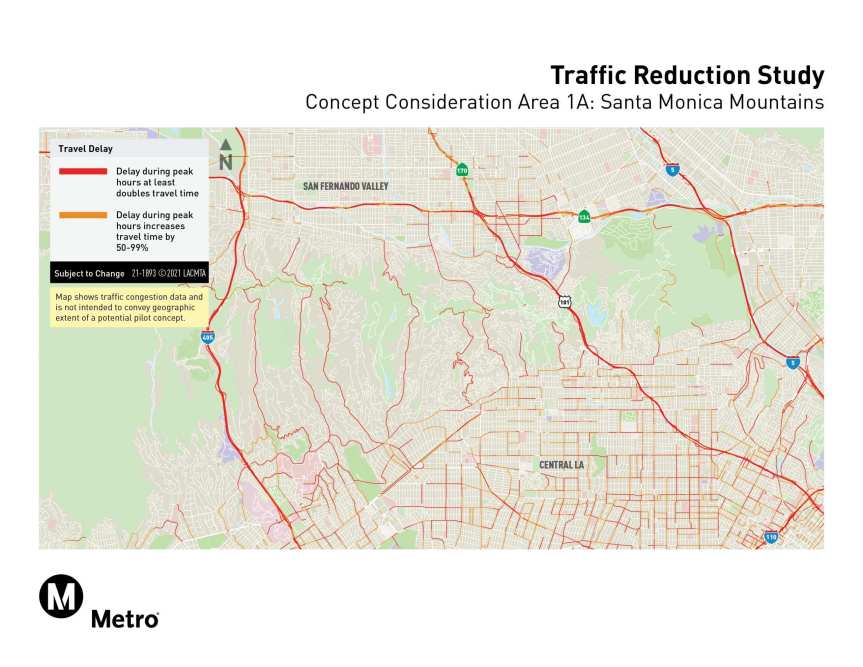
- The Santa Monica Mountains Corridor concept will explore managing traffic on freeways and parallel roadways that cross the Santa Monica Mountains between I-405 and I-5 to reduce heavy congestion from trips between the L.A. Basin and the San Fernando Valley. With few roads across the mountains, terrible traffic has for decades plagued the roads that cross the mountains.
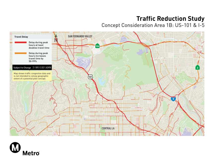
One option could be tolling between I-405 and I-5. Another option would explore a smaller area between US 101 and I-5. Current transit options in this corridor include local and express buses, the D Line (Red) subway run by Metro and two Metrolink commuter rail lines, with future exploration to augment transit and provide more diverse, reliable travel options.
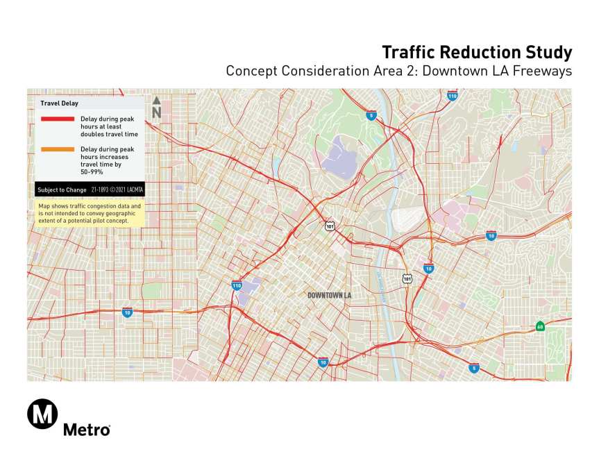
The Downtown L.A. Freeway Corridor concept will explore managing traffic congestion on freeways running to and through downtown L.A. Heavy congestion on these freeways results from trips to downtown or passing through the area. DTLA is served by dozens of bus lines run by Metro and other local bus agencies, several Metro Rail lines (from the San Fernando Valley, San Gabriel Valley, Westside, Long Beach and South Los Angeles) and five Metrolink commuter rail lines. The study would explore adding other transportation improvements as well.
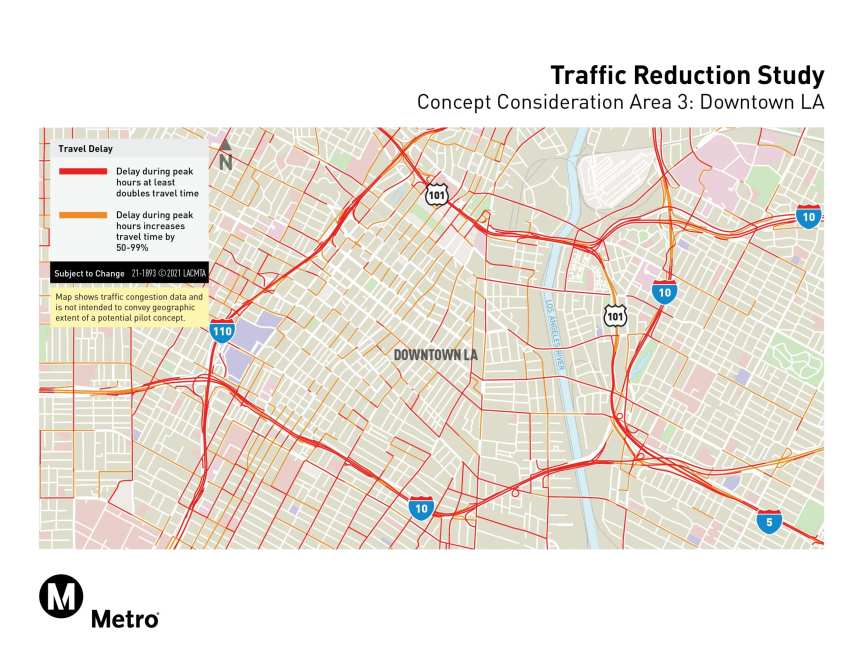
The Downtown L.A. Cordon concept will explore managing traffic coming into the central area of DTLA. This area is bound by several of the most congested freeways in the county, including the I-110, I-10 and US 101. Again, downtown is already home to numerous bus and rail lines and other key projects are under construction. The Regional Connector will tie together three Metro light rail lines for faster trips to and through DTLA with fewer transfers and the D Line (Purple) Extension is extending the subway from downtown all the way to Westwood via Koreatown, the Miracle Mile, Beverly Hills and Century City. Additional transportation improvements would be explored for this area as part of the study.
I-10 Corridor concept west of Downtown L.A. will explore managing traffic on I-10 between Santa Monica and DTLA. There’s heavy congestion between downtown L.A. and communities to the west, including Santa Monica, Culver City and West L.A. To mitigate potential spillover traffic, the I-10 and parallel arterials will be included in the analysis.
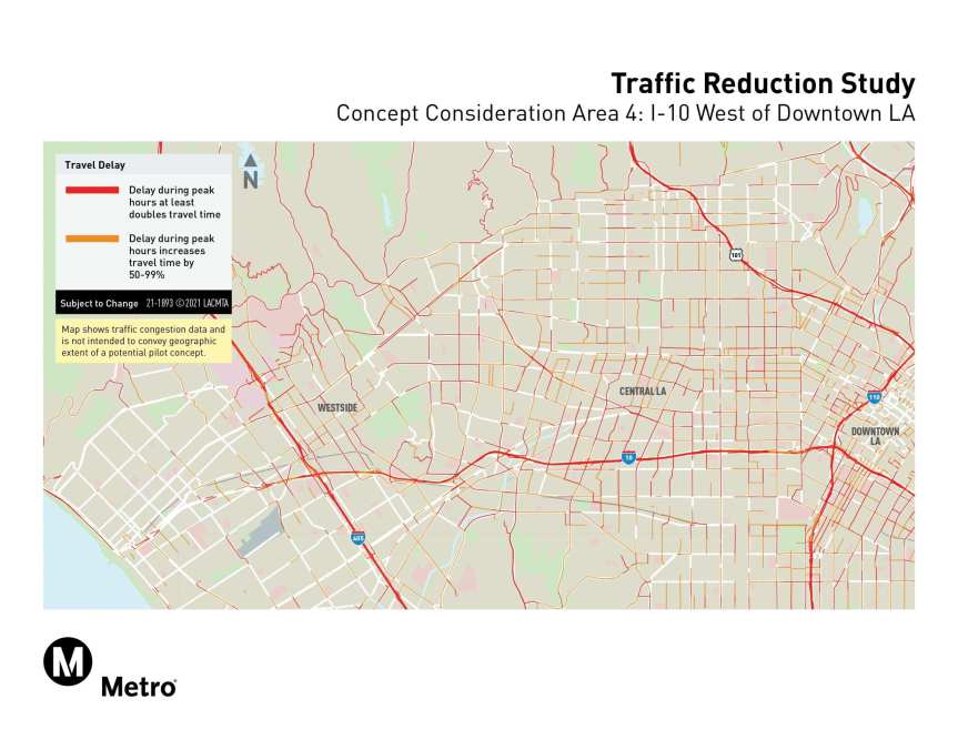
This corridor already has local and express buses and the E Line (Expo) along with the future D Line (Purple) that will run between the Westwood VA Hospital, Century City, Beverly Hills, the Miracle Mile, Koreatown and DTLA. The study will include looking at ways to augment transit and provide more diverse, reliable travel options.
How does congestion pricing work?
Traffic exists because the number of people in cars who want to use the roads (demand) at a particular time is much greater than the actual space available (supply) to handle all of the vehicles.
Congestion pricing is a tool to manage roadway demand. When used as part of a comprehensive strategy to reduce traffic, congestion pricing can encourage some people to change the way they travel some of the time. This could include traveling at a different time; taking a different route; using a different mode, such as taking transit, walking, biking or rolling; carpooling; combining and reducing trips; telecommuting, or; traveling to another destination.
It only takes a small number of people to change the way they travel to have a big impact on traffic. Most people will not be able to make a change, so the price must be low enough to allow people to continue to afford driving, but high enough to encourage some people to change their travel behavior. Equity is a key consideration in any pilot program and fee structure.
The law of supply and demand applies to almost all products and services in the U.S., from housing and utilities to food and other forms of travel. When something that is in short supply is free or inexpensive, demand will be much higher than available supply. Many businesses, utilities, and other entities use pricing to manage demand so that a limited supply can be enough for everyone.
The transit options in my area are not frequent and available enough for my needs. What do you mean by providing high-quality transportation options? I’m not seeing them right now.
Part of the study includes implementing better transportation options before any congestion pricing tolls would be introduced, which is currently anticipated to be in 2025. Improvements could include adding bus or rail service and frequency, better walking and rolling conditions, better and more incentives for carpooling and increased telecommuting options. There are likely other improvements that we will explore as we engage with communities and conduct technical analysis.
In addition to reducing traffic, congestion pricing would also improve the speed and reliability of transit service. With additional improvements on top of these improved conditions, transit can be a true high-quality option for more people.
What is Metro going to do with the revenues from any pilot pricing program?
Any pilot program concept will focus on reducing traffic, providing more high-quality transportation options and supporting other outcomes to improve public health and safety, economic and environmental justice and economic vitality. Based on other programs around the world, we anticipate that congestion pricing would generate funds that could be available to invest in communities served or affected by a pilot program. This would include communities within the geographic boundaries and those whose members travel to or through a pilot area as well. Metro will work with communities and partnering agencies to identify investments that would be made.
When would the tolls take effect?
The project’s current schedule has the Metro Board deciding this summer which concept to continue studying and developing. Upon completion of the study, which is anticipated in Spring 2022, the Metro Board of Directors will decide whether to implement a traffic reduction pilot program in partnership with one or more cities. Getting to an actual operational pilot program would still require federal and state approval, system design and deployment, with a pilot program launch anticipated by 2025.
How could a traffic reduction pilot program support low- or fixed-income county residents and communities, especially those who have historically been disadvantaged or are still recovering from the COVID-19 crisis?
Equity will be a core priority of the Traffic Reduction Study.
While everyone will benefit from less traffic and time savings, not everyone may be able to shoulder the additional costs, even if the price is low.
Each of the concepts that are explored in the study will be analyzed for their potential benefits and burdens on low-income households and communities. Once these have been identified, Metro will work to develop a suite of transportation improvements and low-income assistance programs to increase the benefits and address the burdens. For example, utility services have implemented assistance programs for low-income households to ensure electricity is affordable for everyone.
I already pay lots of taxes. Why are you considering charging me more money to drive?
Congestion pricing is a direct user fee — much the same as paying for electricity, water or other road tolls — and is designed to manage roadway demand and reduce traffic.
Utilities use congestion pricing to ensure that people and businesses have the electricity, water and gas they need when they need it. For example, if we use too much electricity at once during periods of high demand, such as on hot summer afternoons, the grid would be stressed. We would have to worry constantly about blackouts. Pricing is used to avoid this outcome and to shift power usage to other parts of the day. By contrast, our roads are not priced, and, on an almost daily basis, we are subjected to gridlock that has many negative effects on individuals and communities. We’re exploring the use of congestion pricing to manage traffic and provide people with more options to get around L.A. County smoothly — no matter when or how they choose to travel.

The first phase of a study to address the long-term needs of South Orange County is complete and was reviewed by the OCTA Board; work on the study, with ongoing public input, will continue through 2021
Solutions and Community Consensus Drive
OCTA’s South County Study Transportation Study
The Orange County Transportation Authority board recently reviewed the results of the first phase of an ongoing study to address south Orange County’s transportation needs as the area continues to grow with new residents and jobs and as travel patterns and needs evolve.
The study, called the South Orange County Multimodal Transportation Study, is looking at a wide range of transportation needs and solutions over the next 25 years, including improvements to streets, bus and other transit options, highways and bikeways.
The area covered by the study encompasses about 40 percent of Orange County, generally south of State Route 55 to the San Diego County line, and from the coast to the foothills.
“Fundamental to our role at OCTA is our work with the public to understand transportation needs throughout the county,” said Chairman Andrew Do, also Orange County’s First District Supervisor. “With its focus on population and job growth patterns unique to South County, this study will give us valuable insights to help shape a future in which residents and businesses continue to thrive.”
During the first phase of the study conducted in fall 2020, the OCTA team engaged with residents and stakeholders and completed a survey in multiple languages, including English, Spanish, Vietnamese, Korean and Mandarin.
Among the survey findings, the respondents said that they would like to see:
- Reduction in traffic congestion
- Increased frequency and accessibility of multimodal transportation, and
- Increased safety and efficiency for all modes of travel.
The survey also indicated that, in addition to improving and maintaining freeways and streets, those who responded recognize the need to address transportation challenges and want to see an increase in alternative transportation frequency and accessibility.
OCTA, which is Orange County’s transportation planning agency, is responsible for providing a balanced and sustainable transportation system for the entire county. The focus on south Orange County is necessary because over the next 25 years, projections show population growing by 170,000 residents and an additional 130,000 jobs are expected.
At the same time, travel patterns and transportation needs have continued to evolve since OCTA’s last major transportation study of the area in 2008. The projects from that study have resulted in more than a $1.5 billion investment in the area, including OCTA’s I-5 carpool lane project between San Juan Creek Road and Avenida Pico, and OCTA’s I-5 widening between SR-73 and El Toro Road now under construction.
Since the 2008 study, other significant changes have occurred, including a near-term strategy to improve traffic agreed to by OCTA, the Transportation Corridor Agencies (TCA), and Caltrans. That strategy includes:
- Extending the I-5 carpool lanes from Avenida Pico to the border of San Diego County
- Widening Ortega Highway, and
- Extending Los Patrones Parkway as a non-tolled county street.
Other changes have included introduction of mobile transportation apps and on-demand services such as Uber and Lyft, as well as the introduction of community transit options like shuttles and trolleys.
The South County study continues into the second of three phases, scheduled through the end of 2021. Residents, business owners and other key stakeholders will be asked to participate throughout in order to develop community consensus on transportation solutions that should move forward for further development.
For more information, visit: www.octa.net/southocstudy. Click on the “stay connected” tab to sign up for updates.

Now Open! SCAG’s Sustainable Communities Program –
Smart Cities & Mobility Innovations
SCAG is pleased to announce the 2020-2021 Sustainable Communities Program (SCP) – Smart Cities & Mobility Innovations Call for Applications is now open to eligible applicants.
The SCP provides planning resources and technical assistance to local agencies to support the implementation of Connect SoCal, a long-range vision for transportation and land use planning for the region. The program will provide resources for projects that support the implementation of three Connect SoCal key connections, focusing on smart cities and job centers, go zones, and shared mobility/mobility as a service, to expand upon our mobility ecosystems and advance the region’s vision.
Apply now through Friday, April 23, for any of these SCP Smart Cities & Mobility Innovations project types:
- Curb Space Data Collection & Inventory
- Technology Assessment or Adoption Plan
- Parking Management Plan
- Permitting Process Evaluation
To learn more, attend one of the application webinars on March 8 or April 5. Register here to attend. Interested applicants can also sign up for one-to-one coaching sessions with SCAG staff.
Additional calls may be announced. Details will be shared as they become available. For more information on the Sustainable Communities Program, visit scag.ca.gov/scp.

The white-faced Ibis is one of 146 species protected by the Riverside County Multiple Species Habitat Conservation Plan. The Riverside County Transportation Commission is the new managing agency for the Western Riverside County Regional Conservation Authority, which is establishing this 500,000-acre habitat.
Rep. Calvert Reintroduces Bill to Establish
Western Riverside County Wildlife Refuge
Congressman Ken Calvert reintroduced legislation, H.R. 972, establishing the Western Riverside County Wildlife Refuge on February 12. Rep. Mark Takano is an original cosponsor of the bill.
“I continue to support the establishment of the Western Riverside County Wildlife Refuge to conserve our natural resources and provide a solid planning foundation for the county’s future growth and transportation infrastructure,” said Rep. Calvert. “A number of stakeholders throughout the region contribute to the conservation needs of our wildlife. Transferring the land set aside for those needs into a federal wildlife refuge will allow for better management of conserved areas and establish necessary mitigation for our future growth.”
“As Riverside County continues to grow, it’s our responsibility to prioritize conservation and minimize the impact that new developments have on wildlife. That’s why I’m introducing legislation with Rep. Calvert to establish the Western Riverside County Wildlife Refuge,” said Rep. Mark Takano. “We have to protect the wildlife in our region and ensure that our lands are properly and carefully managed.”
The Western Riverside County Regional Conservation Authority (RCA) oversees the Western Riverside County Multiple Species Habitat Conservation Plan (MSHCP), which went into effect in 2004. The MSHCP provides habitat for 146 plant and animal species. Establishing this land as a wildlife refuge will ensure public access and enhanced recreation opportunities for the entire region. Last month, the Riverside County Transportation Commission became the managing agency for the RCA.
“I commend the bipartisan leadership of Representatives Calvert and Takano for reintroducing the Western Riverside County Wildlife Refuge bill,” said RCA Chair and Lake Elsinore City Council Member Natasha Johnson. “A wildlife refuge in western Riverside County will enhance our partnership with the federal government to fulfill our common vision of aligning environmental conservation, infrastructure, and economic growth. By providing habitat and mitigation for endangered and threatened species, the RCA is critical to the quality of living in western Riverside County, and this refuge will be an important part of that success,” she said.
In total, 500,000 acres are required for the wildlife preserve under the MSHCP terms. A total of 350,000 acres are existing land from the Cleveland and San Bernardino National Forests and other state and federal lands, which have reserve value. The remaining 150,000 acres are to be acquired, one-third by state and federal governments and two-thirds from private landowners, through the RCA. Enactment of the bill will enable the U.S. Fish and Wildlife Service to fulfill its obligation as a partner in the MSHCP.
The legislation would:
- Establish the boundary for a new wildlife refuge
- Allow for immediate inclusion of non-federal conservation lands that have already been acquired to meet the terms of the MSHCP
- Provide certainty for development of the transportation infrastructure required to meet the future needs of southern California
- Create new public access and enhance recreation for the entire region
- Create a mechanism for federal agencies to inventory lands within the refuge boundary established by this legislation to determine their suitability for inclusion
Bond Refunding Yields Significant Savings for
Foothill/Eastern Transportation Corridor Agency
![]() The Foothill/Eastern Transportation Corridor Agency (F/ETCA) has executed a bond refunding transaction on certain outstanding 2013A and all 2013C bonds in a move that further strengthens the Agency’s cash position and creates additional flexibility to pay down other bonds early or invest in key capital projects.
The Foothill/Eastern Transportation Corridor Agency (F/ETCA) has executed a bond refunding transaction on certain outstanding 2013A and all 2013C bonds in a move that further strengthens the Agency’s cash position and creates additional flexibility to pay down other bonds early or invest in key capital projects.
“This transaction is another example of how the F/ETCA works in the best interest of the public to reduce debt service and ensure the long-term financial health of the Agency. I commend the work our staff has done to facilitate the continued strong fiscal position of the Agency,” said F/ETCA Chair and Yorba Linda Mayor Peggy Huang.
The refunding decreases annual debt payments every year without extending any bond maturity dates, resulting in a reduction in debt service payments in excess of $210 million net of all transaction costs. The transaction was innovative and contained several components including an exchange of bonds with existing investors, the largest component of the transaction, and publicly sold tax-exempt and taxable bonds. The three components showed strong interest from investors, with current holders retaining over 70 percent of the outstanding bonds through the exchange and more than 50 investors submitting orders for each of the tax-exempt and taxable bond offerings. Demand for the bonds well exceeded the size of the offerings.
The Agency has previously seized upon favorable market conditions such as the low interest rates available today to improve upon the financial position of the Agency. Similar actions in 2017 and 2019 saved the Agency over $400 million in debt payments without extending any bond maturity dates.
“We are committed to working with our elected leadership to seek out ways in which we can serve our nearly 2 million accountholders by further enhancing the Agency’s strong financial position,” said Transportation Corridor Agencies CFO Amy Potter. “We are also proud of the results of our tender and exchange offer and the successful sale of refunding bonds, which shows investor confidence in our credit.”
CEO Samuel Johnson noted that, “TCA’s focus on sound fiscal practices and innovation were on full display with this refunding. Our team evaluated market conditions and developed a strategy that appealed to both current and new investors, resulting in significant savings and strengthening the Agency’s ability to further reduce debt and consider support of regional projects like the Ortega Highway widening and the County’s Los Patrones Extension.”
TCA’s management strengths and long-term financial model have been recognized repeatedly by credit rating agencies including Standard & Poor’s, Fitch and Moody’s, which have rated all of TCA’s bonds as investment grade.

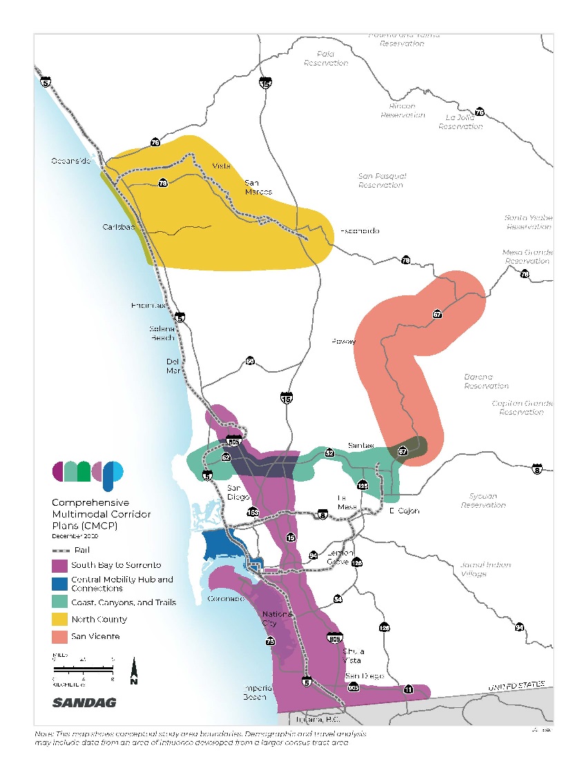
Shaped by public input, Comprehensive Multimodal Corridor Plans are being developed by SANDAG and Caltrans to improve regional transportation.
SANDAG and Caltrans Work Together to
Develop Comprehensive Multimodal Corridor Plans
As part of Senate Bill 1, the Road Repair and Accountability Act of 2017, the San Diego Association of Governments (SANDAG) and the California Department of Transportation District 11 (Caltrans) are working to develop a series of Comprehensive Multimodal Corridor Plans that will serve as blueprints to improve the movement of people and goods across San Diego County.
In accordance with California Transportation Commission directives, Comprehensive Multimodal Corridor Plans are subregional data-driven plans that offer solutions to reduce congestion, support climate action initiatives, generate more transportation choices and economic opportunities, and increase access for residents, commuters, visitors, and goods movement.
These corridor plans provide community context and relevant data on current and anticipated future conditions in predetermined subregional study areas. Additionally, the plans provide communities with an overall concept for the long-term future of a subregional corridor, including guidance and coordination for future improvements necessary to meet corridor plan goals.
Comprehensive Multimodal Corridor Plans evaluate all travel modes and transportation facilities in a defined corridor to identify transportation system improvements and opportunities that will address areas such as congestion, safety, and air quality. These plans seek to support the preservation of local community character and create opportunities for neighborhood enhancement projects. They serve as a foundation that informs decision making on policy, funding, and project development throughout the region by improving multi-modal mobility and accessibility for all Californians, especially low income and disadvantaged communities.
As seen below, the five Comprehensive Multimodal Corridor Plans currently in development cover wide swaths of San Diego County, intersecting many neighborhoods and communities with rich histories
Public participation is vital to the development of each corridor plan and the public will have opportunities to provide input throughout spring and summer. In light of COVID-19 public gathering restrictions, the public can safely participate in the corridor planning process through virtual meetings and briefings as well as digital engagement hubs for each corridor hosted on the Social Pinpoint platform.
SANDAG is working with community-based organizations, tribal representatives, military organizations, and other key stakeholder groups to share information on the corridor plans and ensure equitable outreach is conducted across the region. Through collaboration with these groups, SANDAG is working to ensure that input from Black, Indigenous, People of Color, Environmental Justice, and Limited English Proficiency populations is incorporated into the corridor plans.
The corridor planning process will identify projects, programs, and policies that can help to achieve a balanced transportation system by promoting equity and increasing the quality of life for all San Diegans.
To keep up with the Comprehensive Multimodal Corridor Plans, visit sandag.org/CMCP and follow SANDAG and Caltrans on social media.