
Mobility 21 Advisory Board Member Spotlight:
Steve Agor
Vice President Business Development
Skanska
 Steve Agor, Vice President Business Development for Skanska, leads business development and government affairs efforts for Skanska’s Civil Western United States business. During his 30+ years in the engineering and construction industry, Steve has led the planning, engineering and construction management of complex infrastructure projects. He enjoys working with customers, utilizing his engineering background, to find innovative solutions that work given each project’s unique constraints of the environmental impacts, community needs, budget limitations and project objectives.
Steve currently focuses on Skanska’s strategic business opportunities; including government affairs, joint venture partnering and designer teaming for alternative delivering procurements.
Throughout these efforts, he helps Skanska teams determine the most cost-effective solution that meet or exceed project goals. Through collaborative team efforts during Steve’s tenure, Skanska has been selected as the preferred construction partner for some of the region’s most complex and challenging infrastructure projects.
Prior to joining Mobility 21 as an Advisory Board member, Steve participated on Mobility 21’s Ad-Hoc committee regarding Work Force Development. Volunteering has long been a component of Steve’s professional and personal life. He was President of the California Water Environment Association in 2005, and serves on the Boards for the Los Angeles Area Chamber of Commerce, Southern California Partnerships for Jobs, Transportation California and the American Road and Transportation Builders Association as well currently serving as the Infrastructure Chair for the Inland Empire Economic Partnership. At home, Steve was a 10+ year board member for Lake Forest Little League, served numerous leadership roles for Cub Scout Pack 765 and continues to volunteer as a Little League Umpire.
Steve earned his civil engineering degree from California State University Long Beach, holds a certificate in Project Management from University California Irvine (Extension) and is a Registered Civil Engineer in the State of California. Steve and his wife of nearly 27 years, Lisa, along with their three sons – Koby, Brady and Rory – and their dog Spanky, reside in Lake Forest.
Mobility 21 Advisory Board Member Spotlight:
Samuel Johnson
CEO
Transportation Corridor Agenceies
 Samuel Johnson serves as Chief Executive Officer of the Transportation Corridor Agencies — formed by the California legislature in 1986 to plan, finance, construct and operate the largest network of toll roads in the state.
An award-winning industry thought leader with nearly 30 years of public agency experience, Johnson was appointed CEO in April 2020 and has led the Agencies to key successes against the backdrop of the COVID-19 pandemic. Among his accomplishments, the opening of the $40-million Oso Parkway Bridge; a bond refunding that saved $210 million without extending maturity dates; reaching the milestone of 2,000,000 FasTrak® tolling accounts; and the inception of a program in which cattle graze conserved land to mitigate wildfire risk and promote native vegetation. He is responsible for an average annual budget of nearly $400 million and investment portfolios in excess of $1.5 billion.
Johnson joined TCA in 2015 as Chief Toll Operations Officer, responsible for tolling systems, customer service, revenue management, violation processing, toll compliance, customer experience communications and information technology. He championed the statewide effort to adopt sticker transponders and implemented strategic contracting approaches for systems and services that enhanced customer service and saved the Agencies millions of dollars annually.
Johnson serves as a past president of, both, the International Bridge, Tunnel and Turnpike Association (IBTTA) and the California Toll Operators Committee (CTOC). He is a member of Chapman University’s Board of Governors, an advisory committee that helps the university president and Board of Trustees monitor strategic planning, academic programs and external relations.
Prior to joining TCA, Johnson spent 12 years with the San Diego Association of Governments (SANDAG) overseeing countywide efforts to implement innovative transportation solutions and serving as part of the executive team responsible for the region’s tolling enterprise, including the nation’s first dynamically priced toll facility.
Johnson earned a bachelor’s of science degree in business management with an emphasis in accounting from San Diego State University.

The Orange County Transportation Authority worked with cities to provide grant funding, nearly $3 million in all, to enhance transportation options for seniors and people with disabilities. Photo courtesy of OCTA.
OCTA Awards Nearly $3 Million to Improve
Transportation for Seniors and People with Disabilities
The Orange County Transportation Authority Board of Directors has awarded $2.75 million to local organizations through the Enhanced Mobility for Seniors and Disabled (EMSD) grant program to help meet the transportation needs of seniors and people with disabilities throughout Orange County.
The grants will go to eight nonprofit organizations and public agencies for 14 projects that will provide paratransit vans, buses, support equipment and other assistance to ensure that quality transportation options are available to Orange County seniors and people with disabilities.
The program supports the needs of the senior and disabled populations beyond traditional public transportation. The program may help alleviate demand for OC ACCESS, a shared-ride service OCTA provides for passengers unable to use the regular OC Bus system because of functional and cognitive limitations.
The grant funding will go toward capital expenses such as Americans with Disabilities Act accessible vehicles and related equipment purchases and leases and operating costs. Awarded applicants will also provide matching funds.
OCTA is responsible for coordinating and providing transportation services for seniors and disabled persons within Orange County. OCTA’s Board of Directors released the EMSD call for projects in July, then staff conducted outreach efforts to make local agencies aware of the eligible funding.
OCTA contacted potential applicants – more than 500 in all – such as city, county, and nonprofit agencies that currently participate in OC Go, Senior Mobility and Community Circulator programs and members of the Technical Advisory Committee.
The outreach campaign succeeded in recruiting applicants eager to participate in the EMSD program to secure transportation benefits for the communities they serve.
OCTA will conduct a workshop for those receiving grants to discuss next steps of the program, including reporting and oversight requirements. Following that, they will enter into cooperative agreements with OCTA to receive funding allowing the projects to move forward in 2022.

Public Comment Period Open for Sepulveda
Transit Corridor Environmental Study
Metro is beginning the environmental review phase for the Sepulveda Transit Corridor project, which will build a heavy rail line or monorail between the San Fernando Valley and the Westside. A second phase will eventually be built to LAX.
As part of the environmental review, a formal public comment period will be open from November 30, 2021 through February 11, 2022.
Metro encourages the public to submit comments on the project during this time — including any thoughts on the six alternatives under study (see below) and issues that Metro should consider during the environmental review.
An online presentation on the project is here.
Here’s how to submit comments:
Online Comment Form: https://bit.ly/SepulvedaCommentForm
By mail: Peter Carter, Project Manager
LA Metro
One Gateway Plaza, 99-22-6
Los Angeles, CA 90012
By email: sepulvedatransit@metro.net
By phone: 213.922.7375
Metro will also be holding three virtual meetings in the coming weeks. Each meeting will feature the same information.
Tuesday, January 11, 2022, 6 p.m. to 8 p.m.
Registration: https://zoom.us/webinar/register/WN_QEfrVMtZRFKYZqPVgz26wg
Saturday, January 22, 2022, 10 a.m. to Noon
Registration: https://zoom.us/webinar/register/WN_QwXtjBgbT8qR7-gO8nghzA
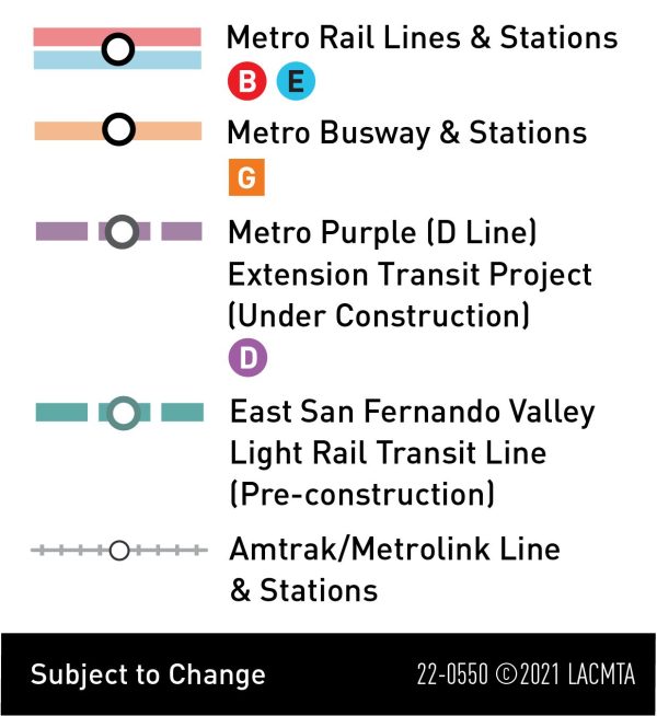
Planning on the project so far has resulted in six alternatives to be studied. Below are the details on each along with a legend that explains the lines on each map:
Alternative 1: Automated monorail that would be entirely aerial along the 405 corridor and the Metrolink Ventura County Line railroad tracks with an electric bus shuttle to UCLA.
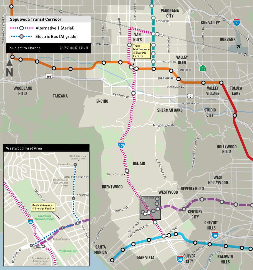
Southern terminus: E Line’s Expo/Sepulveda Station.
Northern terminus: Van Nuys Metrolink Station.
Frequency: every two minutes during peak periods.
Train length/capacity: two to eight cars with an expected six cars during peak periods. Each car could carry up to 76 to 79 passengers
Route notes: 15.3 miles along the 405 corridor and Metrolink’s Ventura County Line tracks.
Stations: Eight aerial stations — near the E Line’s Exposition/Sepulveda Station, Santa Monica Blvd, Wilshire Blvd (transfer to the D Line subway), Getty Center, US-101, G Line’s Sepulveda Station, Sherman Way and the Van Nuys Metrolink Station.
Connection to UCLA: At Wilshire Blvd, an aerial station would be located on the west side of the 405, and an electric bus shuttle would provide service along a 1.4-mile route between the Metro D Line’s Westwood/VA Station and UCLA Gateway Plaza, with intermediate stops at Wilshire Blvd/Veteran Avenue and Westwood Blvd/Le Conte Ave. The electric bus shuttle would operate at the same frequency as the monorail.
Maintenance and storage facilities: A maintenance and storage facility (MSF) for monorail vehicles would be located above the existing parking lot at the Metro G Line Sepulveda Station. Electric buses would be maintained at the existing UCLA BruinBus facility on Veteran north of Kinross Avenue.
Alternative 2: Automated monorail with aerial alignment along the 405 corridor and Metrolink Ventura County Line railroad tracks with an aerial automated people mover connection to UCLA.
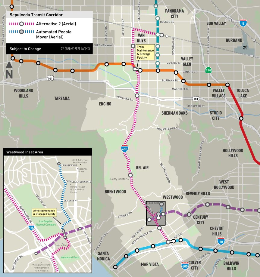
Southern terminus: E Line Expo/Sepulveda Station.
Northern terminus: Van Nuys Metrolink Station.
Frequency: Every two minutes during peak periods.
Train length/capacity: Two to eight cars with six cars in peak periods. Each car could carry up to 76 to 79 passengers.
Route: about 15.8 miles along the 405 corridor— and the Metrolink Ventura County Line tracks.
Stations: Eight aerial stations at Exposition Blvd (Metro E Line), Santa Monica Blvd, Wilshire Blvd (transfer to the D Line subway), the Getty Center, US-101, Metro G Line’s Sepulveda Station, Sherman Way and the Van Nuys Metrolink Station.
Connection to UCLA: A pedestrian bridge would run from the monorail station on the south side of Wilshire to an aerial Automated People Mover (APM) station on the north side of Wilshire. The APM would travel on a structure primarily along Gayley Avenue to an aerial station near the west end of Bruin Walk on the UCLA campus. The people mover would operate at the same frequency as the monorail.
Maintenance and storage facilities: The facility for monorail vehicles would be located above the existing parking lot at the G Line Sepulveda Station. The facility for people mover vehicles would be located above the existing UCLA BruinBus maintenance facility on Veteran Avenue north of Kinross Avenue.
Alternative 3: Automated monorail with aerial segment along the 405 corridor, an underground segment between Wilshire and Getty Center, then entirely aerial along the 405 and Van Nuys Metrolink Line railroad tracks.
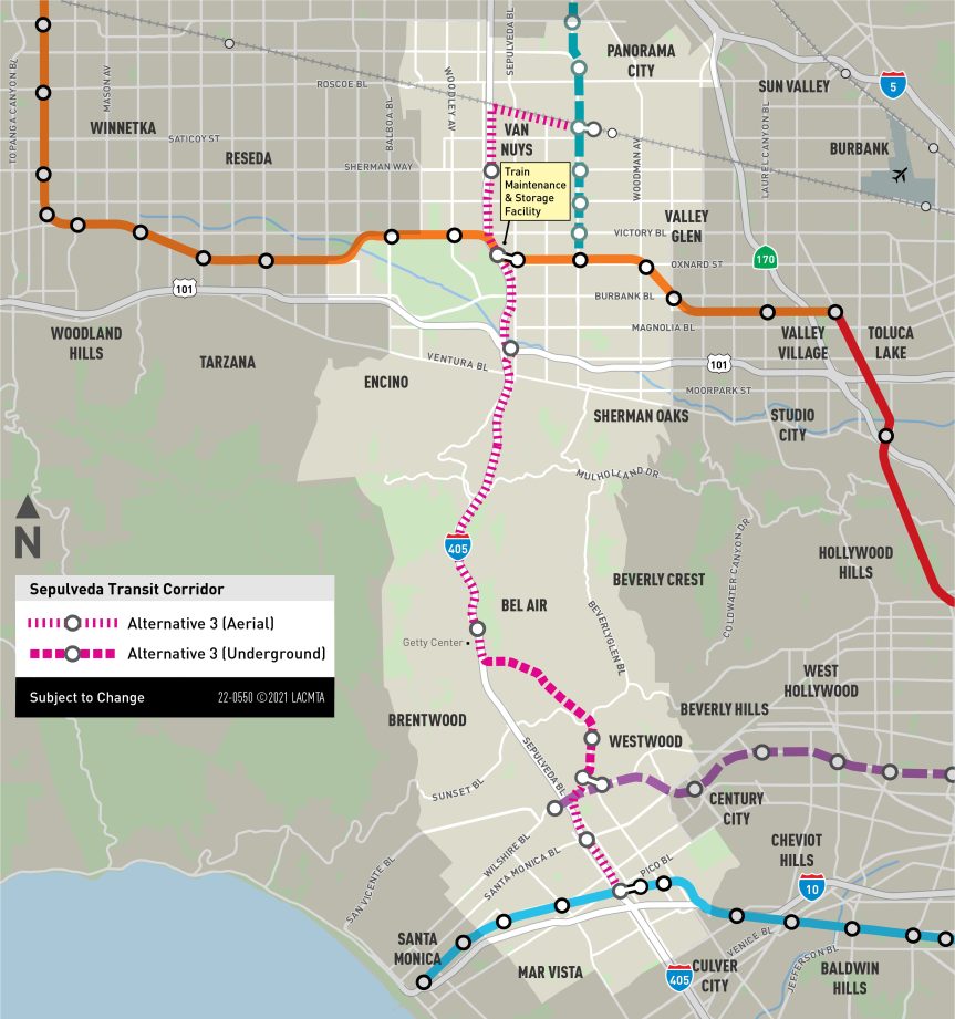
Southern terminus: E Line Expo/Sepulveda Station.
Northern terminus: Van Nuys Metrolink Station.
Frequency: Every two minutes during peak periods.
Train length/capacity: would consist of two to eight cars and are expected to consist of six cars during peak periods, with each car having a capacity of 76 to 79 passengers.
Route: About 16.2 miles that would run along the 405 south of Wilshire, including a 3.3-mile underground segment to serve UCLA, then back to an aerial structure along the 405 with an aerial segment along the Metrolink Ventura County Line tracks.
Stations: Eight aerial stations at Exposition Blvd (Metro E Line), Santa Monica Blvd, Wilshire Blvd (Metro D Line), the Getty Center, US-101, the G Line’s Sepulveda Station, Sherman Way and the Van Nuys Metrolink Station. An underground station would be at UCLA’s Gateway Plaza.
Connection to UCLA: underground monorail station on campus.
Maintenance and storage facility: located above the existing parking lot at the Metro G Line Sepulveda Station.
Alternative 4: Heavy rail with underground segment south of Ventura Blvd and aerial alignment generally along Sepulveda Blvd in the San Fernando Valley.
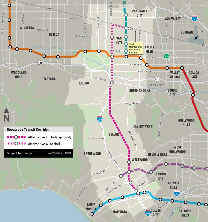
Southern terminus: E Line Expo/Sepulveda Station
Northern terminus: Van Nuys Metrolink Station
Train length/capacity: three cars with each car carrying up to 170 people. Trains could be expanded to four cars.
Frequency: 2.5 minutes in peak periods.
Route: About 14 miles. The line would be underground between the E Line and a portal south of Ventura Blvd in the San Fernando Valley. North of Ventura Blvd, the route would generally be located on an aerial structure above Sepulveda Blvd and the Metrolink Ventura County Line railroad tracks.
Stations: Four underground stations at Exposition Blvd (Metro E Line), Santa Monica Blvd, Wilshire Blvd (Metro D Line) and UCLA’s Gateway Plaza, and four aerial stations at Ventura Blvd, the G Line’s Sepulveda Station, Sherman Way and the Van Nuys Metrolink Station.
Connection to UCLA: an underground rail station would be on campus at Gateway Plaza.
Maintenance and storage facility: located west of Woodman Avenue and south of the Metrolink Ventura County Line railroad tracks.
Alternative 5: Heavy rail with underground segment along Sepulveda Boulevard and an aerial stretch along the Metrolink Ventura County Line tracks in the San Fernando Valley.

Southern terminus: Metro E Line Expo/Sepulveda Station
Northern terminus: Van Nuys Metrolink Station
Train length/capacity: three cars with each car having a capacity of 170 people. Trains could be expanded to four cars.
Frequency: Planned peak hour frequencies of 2.5 minutes.
Route: About 14 miles and similar to Alternative 4 except the alignment along Sepulveda Blvd is also underground, and only aerial segment is along the Metrolink Ventura County Line railroad tracks.
Stations: Seven underground stations at Exposition Blvd (Metro E Line), Santa Monica Blvd, Wilshire Blvd (Metro D Line), UCLA’s Gateway Plaza, Ventura Blvd, the G Line’s Sepulveda Station and Sherman Way. One aerial station would be at the Van Nuys Metrolink Station.
Connection to UCLA: underground rail station on campus at Gateway Plaza.
Maintenance and storage facility: located west of Woodman Avenue and south of the Metrolink Ventura County Line railroad tracks.
Alternative 6: Heavy rail that would be entirely underground including along Van Nuys Blvd in the San Fernando Valley and with a southern terminus station on Bundy Drive next to the E Line on the Westside.
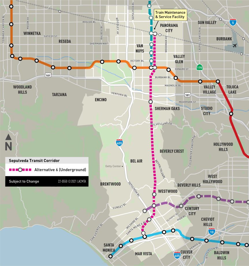
Southern terminus: E Line Expo/Bundy Station.
Northern terminus: Van Nuys Metrolink Station.
Frequency: Planned peak hour frequencies of four minutes.
Train length capacity/length: would consist of two, four or six cars and are expected to consist of six cars during peak periods, with each car having a capacity of 133 passengers.
Route: about 14.6 miles with the segment on the Westside running generally northeast between the E Line Expo/Bundy Station and the UCLA campus. The segment in the San Fernando Valley would follow Van Nuys Blvd.
Stations: Seven underground stations at Olympic Bl (Metro E Line), Santa Monica Blvd (West LA Civic Center), Wilshire Blvd (Metro D Line), UCLA’s Gateway Plaza, Ventura Blvd, the G Line’s Van Nuys Station and the Van Nuys Metrolink Station.
Connection to UCLA: an underground rail station on campus at Gateway Plaza.
Maintenance/storage facility: located east of Van Nuys Blvd and north of the Van Nuys Metrolink Station.
In March, the Metro Board awarded contracts to a two teams to do pre-development (PDA) work on two different potential types of transit the project. LA SkyRail Express is developing the proposed monorail alternatives 1 through 3 listed above while Sepulveda Transit Corridor Partners (STCP) is developing alternatives 4 and 5.
Metro’s Office of Extraordinary Innovation and other agency departments developed the PDA approach that is engaging two firms to develop multiple transit solutions for a complex and congested corridor. The PDA allows Metro to explore the possibility of the private sector investing in the project and taking responsibility for its success – while possibly lowering its cost and helping deliver a better overall project.
We also know that many of your have questions about other aspects of the project, including costs, property acquisitions and when key decisions will be made by the Metro Board of Directors. Please see this extensive Frequently Asked Questions.
The project is funded in part by Measure M, the transportation sales tax approved by 71 percent of L.A. County voters in 2016. The Measure M funding plan includes $5.7 billion for the Valley-Westside segment and $3.8 billion for the Westside-LAX segment.
Metro’s funding plans include assumptions of federal, state, and local revenue — including discretionary grants that Metro must secure through a competitive process. The $1-trillion Infrastructure Jobs and Investment Act signed by President Biden earlier this month could potentially supply funds for this project, as could the $2.2-trillion Build Back Better bill that was approved by the House of Representatives in November and is now before the U.S. Senate.

SCAG is committed to highlighting excellence in sustainable planning and projects in the SCAG Region.
Nominations Now Open for the 2022 SCAG Sustainability Awards
SCAG is now accepting nominations for the 2022 SCAG Sustainability Awards. Each year, SCAG honors projects and plans that best exemplify the core principles of sustainability with awards. These projects and plans are integral to accomplishing the goals of Connect SoCal, the Regional Transportation Plan/Sustainable Communities Strategy, and they promote a cleaner, healthier and happier Southern California.
Past awards have honored a wide range of projects including sustainable water management plans, historic district revitalization projects, city fleet alternative energies policies and more. Nominations are open to all parties. Applications from projects that span across agencies, sectors and geographies are welcome to submit a joint entry.
Now through Thursday, Jan. 13, nominations will be accepted for the following award categories:
- Active, Healthy and Safe Communities
- Clean Cities: Alternative Fuels & Infrastructure
- Efficient & Sustainable Land Use
- Equity
- Green Region Initiative: Resource Conservation & Climate Action
- Housing Innovation
The winners of the SCAG Sustainability Awards will be presented at the 2022 Regional Conference and General Assembly at the JW Marriott Resort & Spa in Palm Desert on May 5-6, 2022.
For more information on the SCAG Sustainability Awards including the award criteria, scoring rubric and nomination form visit scag.ca.gov/sustainabilityawards.

RCTC Chair Jan Harnik Requests Urgent Riverside County Transportation Solutions from Gov. Newsom
Riverside County Transportation Commission (RCTC) Chair Jan Harnik, Mayor Pro Tem of Palm Desert, sent a letter Friday to Gov. Gavin Newsom to applaud his attention and collaborative approach to addressing traffic congestion on southbound Interstate 15 near the California-Nevada Border, and to ask that the governor apply the same urgency to reduce debilitating congestion in Riverside County.
On December 5, Gov. Newsom jointly announced with Nevada Gov. Steve Sisolak plans to expand I-15 between the Nevada border and the California Agricultural Inspection Station with a new, temporary lane to be added to the shoulder. According to Gov. Newsom, this action provides traffic congestion relief that has frustrated travelers on I-15. In his news release, the governor called the expansion, “crucial for continued economic health and resilience in the region and beyond.”
In her letter, Chair Harnik emphasized the urgent need for state action.
“Riverside County, like the California-Nevada border, also has longstanding traffic issues that we have worked to address. While we appreciate the state’s assistance to date, we frankly need much more. We need a proactive partnership and strategy from the state to bring traffic relief to this region.”
She also stated, “The well-being and prosperity of our disadvantaged communities depend on it, as do the state and national economies. While multimodal transportation systems are vital to future mobility, roads and highway expansion cannot be discounted as a tool that helps keep people and goods moving.”
From the 2002 voter-approved Measure A transportation sales tax to the 2020 Commission-approved Traffic Relief Plan, RCTC continues to develop and deliver critical transportation improvements, with limited resources, to meet the infrastructure needs of a region experiencing unprecedented population growth and goods movement traffic.
Chair Harnik has asked Gov. Newsom to call her to discuss how he may partner with RCTC to make meaningful improvements to the lives of Riverside County’s working families.
Read full letter here. For more information, go to rctc.org/support

SANDAG Board Adopts 2021 Regional Plan,
Advancing Bold Transportation Vision for the San Diego Region
On December 10, 2021, the San Diego Association of Governments (SANDAG) Board of Directors adopted the 2021 Regional Plan and certified its Environmental Impact Report (EIR).
The 2021 Regional Plan is a long-term blueprint for the San Diego region through 2050 that incorporates the latest technologies, meets all state and federal requirements and air quality mandates, addresses traffic congestion and roadway safety, and improves social equity. The plan will make it easier for everyone in the San Diego region to get where they need to go, whether you choose to walk, ride, drive, or bike.
The 2021 Regional Plan was developed through years of public input and a data-driven approach that analyzed where people live and work, how they get around, and what improvements are needed in existing transportation infrastructure to support future growth. With this analysis and innovative solutions, the 2021 Regional Plan will provide the San Diego region with faster, more equitable, environmentally sustainable ways of traveling.
While the plan includes improvements 30 years into the future, SANDAG will immediately start working to advance projects, including but not limited to:
- Opening the new Otay Mesa East Port of Entry and Smart Border Management System
- Relocating the LOSSAN rail corridor off the coastal bluffs
- Advancing the Central Mobility Hub to provide direct transit connections to San Diego International Airport
- Blue Line Express
- Purple Line
- San Ysidro Mobility Hub
- Regional Vision Zero action plan and policy
- Digital Equity Action Plan
Stay up-to-date on the 2021 Regional Plan and other SANDAG projects by following SANDAG on social media – Facebook, Instagram, LinkedIn, and Twitter – and make sure you’re subscribed to SANDAG’s email list for the latest news and updates.